↓
 

Colorado Springs Land Surveying

Local Land Surveyors in Colorado Springs, CO

Colorado Springs Land Surveying
  • Home
  • ALTA Survey
  • Boundary Surveying
  • Construction Survey
  • Drone LiDAR Mapping
  • Elevation Certificate
  • Land Surveying
  • Topographic Survey
  • Blog
  • Contact Us
Home - Page 3 << 1 2 3 4 5 … 8 9 >>

Post navigation

← Older posts
Newer posts →

Why Property Survey Cost Varies So Much From Job to Job

Colorado Springs Land Surveying Posted on June 8, 2026 by ColoradoSpringsSurveyorJune 4, 2026
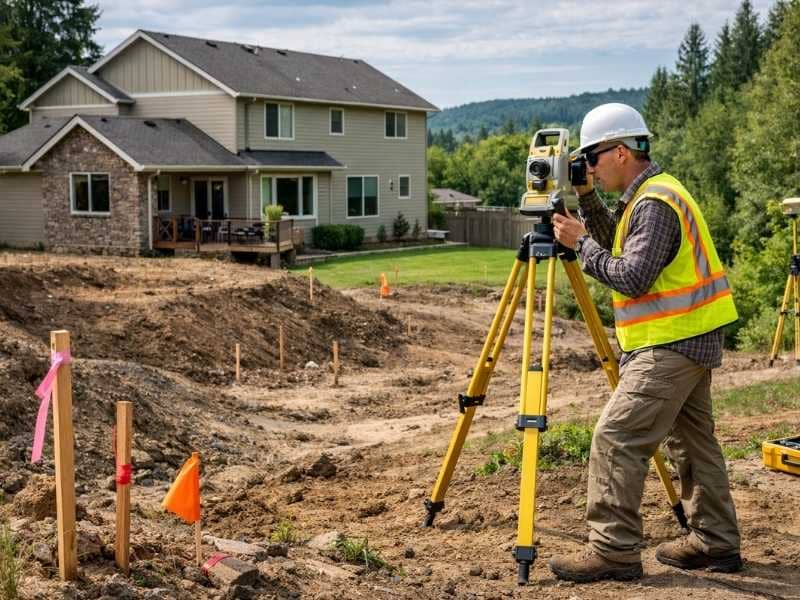
Surveyor using GPS equipment on uneven terrain, showing how property survey cost can vary depending on land conditions and property complexity

If you have ever gotten two quotes for a property survey and wondered why the numbers were so far apart, you are not imagining things. Property survey costs genuinely shift from one job to the next, sometimes by hundreds of dollars, and there are real reasons behind it. The price reflects the actual work involved, and no two properties are exactly the same.

Every Property Is a Different Job

A flat, quarter-acre lot in a newer Colorado Springs subdivision is a straightforward job. A two-acre hillside property on the edge of town with no recent survey on record is a completely different situation. The same type of survey applied to both will cost very different amounts because the work required is not the same.

Surveyors price jobs based on time and complexity. When a property is simple and well-documented, the job moves quickly. When it is not, the hours stack up fast.

The Factors That Change the Price Most

Size of the Property

More land means more ground to cover, more corners to locate, and more measurements to take. A small residential lot might take a crew a few hours. A larger parcel can take a full day or more, and that difference shows up directly in the final price.

Shape and Number of Corners

A simple rectangular lot has four corners. Some properties have eight, ten, or more, with irregular edges, cutouts, or easements running through them. Each corner has to be located, measured, and documented. The more corners a property has, the longer the survey takes.

Terrain and Ground Conditions

Colorado Springs sits at the base of the Rockies, and a lot of the land here is anything but flat. Steep slopes, rocky ground, dense vegetation, and elevation changes all slow fieldwork down. Equipment is harder to move, sightlines are harder to maintain, and some areas simply take more time to work through safely. Difficult terrain is one of the biggest cost drivers in this region.

Age and Condition of Existing Records

Before a surveyor sets foot on your property, they spend time in the office researching it. They look at deeds, prior surveys, county records, and legal descriptions on file. If your property has a clean, recent survey and clear records, that research goes quickly. If the records are old, inconsistent, or incomplete, the research phase takes significantly longer and adds real cost to the job.

Older properties in Colorado Springs, especially those in established neighborhoods or rural areas platted decades ago, sometimes have records that do not match what is on the ground. Resolving those gaps takes experience and time.

Whether Monuments Are Still in Place

Survey monuments are the physical markers set in the ground to identify property corners. If previous markers are still in place and undisturbed, a surveyor can work from them efficiently. If they have been moved, removed, or buried over the years, the surveyor has to work harder to re-establish those points. That extra effort costs more.

Accessibility of the Site

If a crew can pull up to your property, unload, and get to work without obstacles, the job runs smoothly. If the land is gated, fenced, heavily wooded, or requires crossing neighboring parcels, the logistics get complicated. Some properties in and around Colorado Springs require special access arrangements that add time before fieldwork even starts.

Type of Survey Affects the Price Too

Not all surveys produce the same result, and the type you need will affect your cost significantly.

A basic boundary survey focuses on locating and confirming property lines. A topographic survey adds elevation data and surface features, which takes more time and equipment. An ALTA survey, commonly required for commercial transactions, follows a strict national standard that demands a higher level of detail and documentation. Each step up in complexity comes with a corresponding step up in price.

Why Two Quotes for the Same Property Can Still Differ

Even when two firms are quoting the same job, their prices can vary. Experience level, equipment, office overhead, current workload, and how each firm calculates labor rates all play a role. A firm that is booked solid may quote higher than one with open capacity. A firm that specializes in residential work may price differently than one focused on commercial projects.

That is why it makes sense to get more than one quote, but also to look beyond price. A lower number does not always mean better value if the turnaround is longer or the firm has less experience with properties like yours.

Frequently Asked Questions

Can I get a rough estimate before a surveyor visits my property?

Yes, most surveying firms will provide a preliminary estimate based on your property address, lot size, and the type of survey you need. The final quote may change once they review county records and assess any site conditions that affect the scope of work.

Does a survey cost more if my property has never been surveyed before?

It often does. When there is no prior survey on record, the surveyor has to establish everything from scratch using deeds, legal descriptions, and neighboring boundary data. That takes more research and fieldwork than updating or verifying an existing survey.

Will a boundary dispute increase my survey cost?

Yes. When neighboring property lines are contested, the surveyor may need to research multiple properties, review chain of title documents, and spend additional time reconciling conflicting records. That added complexity is reflected in the price.

Does the time of year affect survey pricing?

It can. Winter conditions, snow cover, and frozen ground can slow fieldwork and limit access to certain areas. Some firms adjust their scheduling or pricing during peak demand periods, particularly in spring when development activity picks up across the region.

Is a survey from five years ago still accurate enough to use?

It depends on what has changed. If no construction, fencing, or boundary activity has occurred since the last survey, it may still be valid for many purposes. However, lenders, title companies, and certain permits often require a current survey. A licensed surveyor can review your existing document and advise whether a new one is needed.

Posted in boundary surveying | Tagged boundary survey

Land Survey Cost: What Are You Actually Paying For?

Colorado Springs Land Surveying Posted on June 5, 2026 by ColoradoSpringsSurveyorJune 4, 2026
Licensed land surveyor performing fieldwork on a residential property, illustrating the factors that influence land survey cost

If you have ever asked for a land survey cost estimate and felt confused by the number you got back, you are not alone. The price can range from a few hundred dollars to several thousand, and it is not always clear what drives that difference. This guide breaks it down in plain terms so you know exactly what goes into the quote before you sign anything.

What Does a Land Survey Cost?

A standard residential boundary survey typically runs between $500 and $2,500. Most homeowners land somewhere in the middle of that range. Commercial properties and more complex survey types, like ALTA surveys, can push costs to $5,000 or higher.

The national average for a land survey sits around $526, with most jobs falling between $376 and $745. Colorado pricing tends to run slightly higher due to the terrain and the volume of surveying work in a growing metro area like Colorado Springs.

Average Cost by Survey Type

  • Boundary survey: $500 to $1,500
  • Topographic survey: $1,000 to $2,000
  • ALTA/NSPS survey: $2,000 to $5,000 or more
  • As-built survey: $800 to $2,500

What Factors Drive the Price Up or Down?

Land survey cost is not set by a flat rate. Several things can push the number higher or lower, and most of them come down to how much time and effort the job requires.

Property Size and Shape

Larger properties take longer to survey. Odd-shaped lots with many corners or angles also require more time than a simple rectangular parcel. The more points a surveyor has to measure and document, the higher the cost.

Terrain and Accessibility

Colorado Springs is surrounded by hills, slopes, and areas that are not easy to walk through with equipment. Steep or wooded terrain slows fieldwork down considerably. Properties that are hard to access, whether due to elevation, dense brush, or distance from a road, will cost more to survey.

Age of Property Records

Older properties often have incomplete or inconsistent records. If the surveyor has to spend extra time researching deed history, digging through county archives, or tracking down original monuments, that research time is factored into your quote. Properties with disputed or unclear history can take 20 to 40 percent longer to survey.

Turnaround Time

Standard turnaround for a residential survey is usually one to three weeks. If you need it done faster, most firms can accommodate a rush, but expect to pay a premium for it.

What Is Included in a Land Survey Quote?

A good quote from a licensed surveyor should not just be a dollar amount. It should tell you what you are getting. Here is what a complete quote typically covers:

  • Fieldwork, meaning the actual time spent on your property measuring and locating markers
  • Research into public records, deeds, and prior surveys
  • Drafting of the final survey document or plat
  • Review and sign-off by a licensed professional land surveyor
  • Setting or locating property corners and markers

Colorado has more than 1,200 licensed professional land surveyors registered with the state board. Every survey that gets stamped and signed has gone through a professional review process, and that oversight is part of what you are paying for.

Is a Cheaper Survey Ever a Good Idea?

It depends on what you need the survey for. If you are settling a boundary dispute, buying property, or securing a construction permit, cutting corners on a survey is a mistake that can cost far more to fix later.

A lower price sometimes means less time spent on research, which can lead to errors. It can also mean the survey was done by someone without full licensure. In Colorado, only a licensed professional land surveyor can legally certify a survey. Always verify credentials before hiring.

How to Get an Accurate Quote

Before you call a surveying company, gather a few pieces of information. Having these ready will help you get a faster and more accurate estimate:

  • Your property address and parcel number
  • The approximate size and shape of your lot
  • The type of survey you need or what you are trying to accomplish
  • Any existing surveys or plats you already have

Getting quotes from more than one firm is always a good idea, but do not make price the only factor. Experience with Colorado Springs terrain, turnaround time, and communication style all matter when choosing who to work with.
Posted in land surveying | Tagged Land Surveying

Welcome to Colorado Springs Land Surveying

Colorado Springs Land Surveying Posted on August 18, 2017 by ColoradoSpringsSurveyorApril 15, 2020

Your Final Stop for ALL of Your Survey Needs!                                         Contact us today for a free quote!

This site is intended to provide you with information on Land Surveying in the Colorado Springs, CO and El Paso County area of Colorado. If you’re looking for a Colorado Springs Land Surveyor, you’ve come to the right place. If you’d rather talk to someone about your land surveying needs, please call our local number at (719) 722 2536 today. For more information, please continue to read.

land surveyingLand Surveyors are professionals who make precise measurements to determine the size and boundaries of a piece of real estate.  While this is a simplistic definition, boundary surveying is one of the most common types of surveying related to home and land owners. If you fall into the following categories, please click on the appropriate link for more information on that subject:

Colorado Springs Land Surveying services:

    1. I need to know where my property corners or property lines are. (Boundary Survey)
    2. I have a loan closing or re-finance coming up on my home in a subdivision. (Lot Survey)
    3. I need a map of my property with contour lines to show elevation differences for my architect or engineer. (Topo Survey)
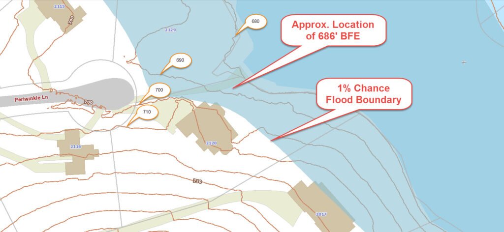
    4. I’ve just been told I’m in a flood zone or I’ve been told I need an elevation certificate in order to obtain flood insurance or prove I don’t need it. (Flood Survey)
    5. I’m purchasing a lot/house in a recorded subdivision. (Lot Survey – See Boundary Survey if you’re not in a subdivision.)
    6. I’m purchasing a larger tract of land, acreage, that hasn’t been subdivided in the past. (Boundary Survey)

Contact Colorado Springs Land Surveying services TODAY at (719) 722 2536.

Posted in boundary surveying, elevation certificate, land surveying, land surveyor | Tagged boundary survey, Colorado Springs Land Surveying, land surveyor, land surveyor colorado-springs co

Post navigation

← Older posts
Newer posts →
Get Quote Button
© Boxer Survey USA
Colorado Springs Land Surveying

Colorado Springs, Colorado
Phone: (719) 722 2536

Web Development and SEO by:
AuburnBusiness.Com, LLC


Privacy Policy | Terms of Use

The owner of this website, Boxer Survey USA, provides coordination of professional land surveying and engineering services in all 50 states. The professional surveying and engineering services provided to you will be conducted by fully licensed professionals in your state.

↑